|
|
|||||||||||||||||
| Point ID: 6145 | Downloads | Plots | Site Data | Code: 3029 |
|
|
|||||||||||||||||
| Download | |
|---|---|
| Site Descriptor Information | Site Time Series Data |
| Link to all available data | |
| View: | Time Series | All |
| Units: | m3/s |
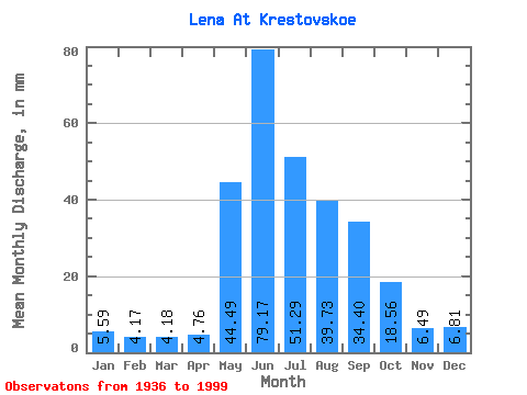
| Statistic | Jan | Feb | Mar | Apr | May | Jun | Jul | Aug | Sep | Oct | Nov | Dec | Annual |
|---|---|---|---|---|---|---|---|---|---|---|---|---|---|
| Mean | 5.59 | 4.21 | 4.18 | 4.76 | 44.48 | 79.17 | 51.28 | 39.72 | 34.40 | 18.55 | 6.49 | 6.81 | 298.75 |
| Standard Deviation | 1.23 | 0.86 | 0.80 | 1.78 | 9.90 | 19.26 | 15.51 | 13.80 | 11.53 | 5.13 | 1.81 | 1.57 | 44.02 |
| Min | 3.45 | 2.08 | 2.81 | 3.02 | 24.40 | 36.99 | 22.52 | 20.69 | 17.32 | 11.02 | 2.88 | 2.39 | 207.48 |
| Max | 8.64 | 6.32 | 6.27 | 15.02 | 67.56 | 122.53 | 97.38 | 81.56 | 68.92 | 31.65 | 12.61 | 10.41 | 433.99 |
| Coefficient of Variation | 0.22 | 0.20 | 0.19 | 0.38 | 0.22 | 0.24 | 0.30 | 0.35 | 0.34 | 0.28 | 0.28 | 0.23 | 0.15 |
 Return to R-Arctic Net Home Page