|
|
|||||||||||||||||
| Point ID: 6074 | Downloads | Plots | Site Data | Code: 7188 |
|
|
|||||||||||||||||
| Download | |
|---|---|
| Site Descriptor Information | Site Time Series Data |
| Link to all available data | |
| View: | Time Series | All |
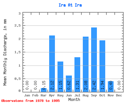
| Units: | m3/s |
| Statistic | Jan | Feb | Mar | Apr | May | Jun | Jul | Aug | Sep | Oct | Nov | Dec | Annual |
|---|---|---|---|---|---|---|---|---|---|---|---|---|---|
| Mean | 0.00 | 0.00 | 0.15 | 2.12 | 1.15 | 0.62 | 1.30 | 2.08 | 2.42 | 1.94 | 0.40 | 0.00 | 13.58 |
| Standard Deviation | 0.00 | 0.00 | 0.25 | 1.60 | 1.36 | 0.62 | 1.67 | 2.12 | 2.24 | 1.79 | 0.48 | 0.01 | 8.96 |
| Min | 0.00 | 0.00 | 0.00 | 0.56 | 0.31 | 0.14 | 0.15 | 0.25 | 0.23 | 0.29 | 0.01 | 0.00 | 2.58 |
| Max | 0.00 | 0.00 | 0.78 | 7.23 | 5.97 | 2.68 | 5.29 | 6.84 | 6.48 | 5.14 | 1.55 | 0.05 | 26.30 |
| Coefficient of Variation | 1.64 | 0.75 | 1.18 | 1.00 | 1.28 | 1.02 | 0.92 | 0.92 | 1.20 | 3.08 | 0.66 |
 Return to R-Arctic Net Home Page