|
|
|||||||||||||||||
| Point ID: 605 | Downloads | Plots | Site Data | Code: 07AD007 |
|
|
|||||||||||||||||
| Download | |
|---|---|
| Site Descriptor Information | Site Time Series Data |
| Link to all available data | |
| View: | Time Series | All |
| Units: | m3/s |
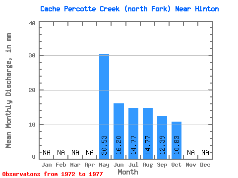
| Statistic | Jan | Feb | Mar | Apr | May | Jun | Jul | Aug | Sep | Oct | Nov | Dec | Annual |
|---|---|---|---|---|---|---|---|---|---|---|---|---|---|
| Mean | 30.85 | 16.44 | 14.96 | 15.26 | 11.91 | 10.99 | |||||||
| Standard Deviation | 38.29 | 14.08 | 18.39 | 18.93 | 16.19 | 11.69 | |||||||
| Min | 4.92 | 2.86 | 2.95 | 0.98 | 0.95 | 0.98 | |||||||
| Max | 74.83 | 36.21 | 47.26 | 52.18 | 43.84 | 28.55 | |||||||
| Coefficient of Variation | 1.24 | 0.86 | 1.23 | 1.24 | 1.36 | 1.06 |
 Return to R-Arctic Net Home Page