|
|
|||||||||||||||||
| Point ID: 6045 | Downloads | Plots | Site Data | Code: 7030 |
|
|
|||||||||||||||||
| Download | |
|---|---|
| Site Descriptor Information | Site Time Series Data |
| Link to all available data | |
| View: | Time Series | All |
| Units: | m3/s |
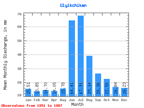
| Statistic | Jan | Feb | Mar | Apr | May | Jun | Jul | Aug | Sep | Oct | Nov | Dec | Annual |
|---|---|---|---|---|---|---|---|---|---|---|---|---|---|
| Mean | 15.50 | 13.97 | 14.73 | 14.02 | 15.75 | 64.41 | 67.90 | 39.17 | 26.35 | 22.54 | 16.82 | 16.21 | 326.56 |
| Standard Deviation | 2.73 | 3.57 | 3.17 | 3.25 | 3.80 | 14.89 | 32.41 | 22.77 | 9.59 | 5.13 | 3.23 | 2.97 | 63.79 |
| Min | 10.82 | 9.04 | 9.92 | 7.50 | 7.03 | 32.29 | 23.44 | 16.23 | 13.96 | 14.43 | 11.35 | 11.72 | 232.80 |
| Max | 22.54 | 27.11 | 23.44 | 20.95 | 27.05 | 96.00 | 203.78 | 104.59 | 56.73 | 34.26 | 24.44 | 23.44 | 555.75 |
| Coefficient of Variation | 0.18 | 0.26 | 0.22 | 0.23 | 0.24 | 0.23 | 0.48 | 0.58 | 0.36 | 0.23 | 0.19 | 0.18 | 0.20 |
 Return to R-Arctic Net Home Page