|
|
|||||||||||||||||
| Point ID: 603 | Downloads | Plots | Site Data | Code: 07AD005 |
|
|
|||||||||||||||||
| Download | |
|---|---|
| Site Descriptor Information | Site Time Series Data |
| Link to all available data | |
| View: | Time Series | All |
| Units: | m3/s |
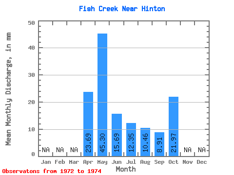
| Statistic | Jan | Feb | Mar | Apr | May | Jun | Jul | Aug | Sep | Oct | Nov | Dec | Annual |
|---|---|---|---|---|---|---|---|---|---|---|---|---|---|
| Mean | 23.69 | 45.30 | 15.74 | 12.34 | 10.50 | 8.96 | 21.97 | ||||||
| Standard Deviation | 6.07 | 8.09 | 4.08 | 3.66 | 4.08 | ||||||||
| Min | 23.69 | 41.01 | 10.02 | 7.95 | 6.28 | 6.08 | 21.97 | ||||||
| Max | 23.69 | 49.59 | 21.46 | 16.00 | 12.87 | 11.85 | 21.97 | ||||||
| Coefficient of Variation | 0.13 | 0.51 | 0.33 | 0.35 | 0.46 |
 Return to R-Arctic Net Home Page