|
|
|||||||||||||||||
| Point ID: 602 | Downloads | Plots | Site Data | Code: 07AD004 |
|
|
|||||||||||||||||
| Download | |
|---|---|
| Site Descriptor Information | Site Time Series Data |
| Link to all available data | |
| View: | Time Series | All |
| Units: | m3/s |
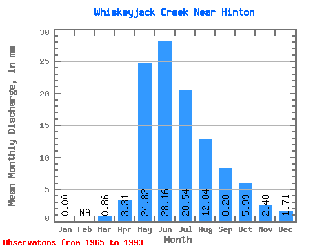
| Statistic | Jan | Feb | Mar | Apr | May | Jun | Jul | Aug | Sep | Oct | Nov | Dec | Annual |
|---|---|---|---|---|---|---|---|---|---|---|---|---|---|
| Mean | 0.00 | 0.43 | 3.15 | 24.63 | 28.36 | 20.40 | 12.50 | 8.43 | 6.27 | 2.48 | 1.28 | ||
| Standard Deviation | 0.60 | 2.30 | 19.84 | 23.45 | 19.68 | 13.83 | 7.63 | 5.98 | 2.21 | 0.72 | |||
| Min | 0.00 | 0.00 | 0.83 | 2.57 | 3.31 | 2.57 | 0.86 | 0.83 | 0.86 | 0.83 | 0.86 | ||
| Max | 0.00 | 0.86 | 6.62 | 75.29 | 100.20 | 78.71 | 59.04 | 32.30 | 21.39 | 6.62 | 2.57 | ||
| Coefficient of Variation | 1.41 | 0.73 | 0.81 | 0.83 | 0.96 | 1.11 | 0.91 | 0.95 | 0.89 | 0.56 |
 Return to R-Arctic Net Home Page