|
|
|||||||||||||||||
| Point ID: 601 | Downloads | Plots | Site Data | Code: 07AD003 |
|
|
|||||||||||||||||
| Download | |
|---|---|
| Site Descriptor Information | Site Time Series Data |
| Link to all available data | |
| View: | Time Series | All |
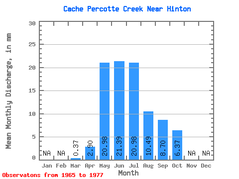
| Units: | m3/s |
| Statistic | Jan | Feb | Mar | Apr | May | Jun | Jul | Aug | Sep | Oct | Nov | Dec | Annual |
|---|---|---|---|---|---|---|---|---|---|---|---|---|---|
| Mean | 0.19 | 2.90 | 20.90 | 21.43 | 21.11 | 10.32 | 8.76 | 6.30 | |||||
| Standard Deviation | 0.27 | 3.08 | 15.26 | 15.37 | 25.55 | 10.98 | 12.07 | 7.70 | |||||
| Min | 0.00 | 0.72 | 8.99 | 3.26 | 2.62 | 0.38 | 0.36 | 0.38 | |||||
| Max | 0.38 | 5.08 | 51.31 | 46.77 | 72.29 | 31.46 | 39.51 | 23.60 | |||||
| Coefficient of Variation | 1.41 | 1.06 | 0.73 | 0.72 | 1.21 | 1.06 | 1.38 | 1.22 |
 Return to R-Arctic Net Home Page