|
|
|||||||||||||||||
| Point ID: 5947 | Downloads | Plots | Site Data | Code: 1605 |
|
|
|||||||||||||||||
| Download | |
|---|---|
| Site Descriptor Information | Site Time Series Data |
| Link to all available data | |
| View: | Time Series | All |
| Units: | m3/s |
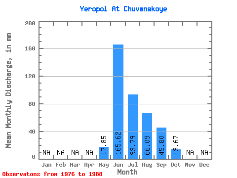
| Statistic | Jan | Feb | Mar | Apr | May | Jun | Jul | Aug | Sep | Oct | Nov | Dec | Annual |
|---|---|---|---|---|---|---|---|---|---|---|---|---|---|
| Mean | 17.84 | 165.62 | 93.78 | 66.08 | 45.80 | 13.67 | |||||||
| Standard Deviation | 14.48 | 44.82 | 48.65 | 31.79 | 34.40 | 10.49 | |||||||
| Min | 1.23 | 82.16 | 30.53 | 11.34 | 10.91 | 3.04 | |||||||
| Max | 41.64 | 226.34 | 173.30 | 104.43 | 114.41 | 33.96 | |||||||
| Coefficient of Variation | 0.81 | 0.27 | 0.52 | 0.48 | 0.75 | 0.77 |
 Return to R-Arctic Net Home Page