|
|
|||||||||||||||||
| Point ID: 5937 | Downloads | Plots | Site Data | Code: 1585 |
|
|
|||||||||||||||||
| Download | |
|---|---|
| Site Descriptor Information | Site Time Series Data |
| Link to all available data | |
| View: | Time Series | All |
| Units: | m3/s |
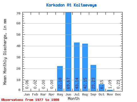
| Statistic | Jan | Feb | Mar | Apr | May | Jun | Jul | Aug | Sep | Oct | Nov | Dec | Annual |
|---|---|---|---|---|---|---|---|---|---|---|---|---|---|
| Mean | 0.06 | 0.02 | 0.00 | 0.00 | 22.18 | 69.67 | 43.13 | 42.14 | 23.23 | 6.15 | 1.09 | 0.23 | 211.05 |
| Standard Deviation | 0.09 | 0.03 | 0.00 | 0.00 | 12.78 | 28.79 | 24.31 | 20.90 | 7.87 | 2.35 | 0.92 | 0.22 | 57.33 |
| Min | 0.00 | 0.00 | 0.00 | 0.00 | 0.81 | 26.56 | 21.37 | 13.51 | 11.39 | 3.88 | 0.30 | 0.01 | 157.00 |
| Max | 0.19 | 0.05 | 0.00 | 0.00 | 44.34 | 119.29 | 106.49 | 72.97 | 35.15 | 10.23 | 2.99 | 0.57 | 271.17 |
| Coefficient of Variation | 1.66 | 1.73 | 0.58 | 0.41 | 0.56 | 0.50 | 0.34 | 0.38 | 0.84 | 0.97 | 0.27 |
 Return to R-Arctic Net Home Page