|
|
|||||||||||||||||
| Point ID: 592 | Downloads | Plots | Site Data | Code: 07AC002 |
|
|
|||||||||||||||||
| Download | |
|---|---|
| Site Descriptor Information | Site Time Series Data |
| Link to all available data | |
| View: | Time Series | All |
| Units: | m3/s |
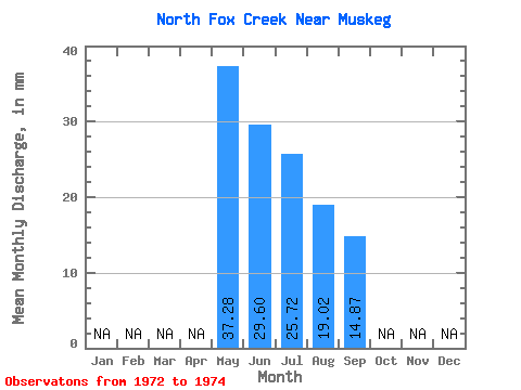
| Statistic | Jan | Feb | Mar | Apr | May | Jun | Jul | Aug | Sep | Oct | Nov | Dec | Annual |
|---|---|---|---|---|---|---|---|---|---|---|---|---|---|
| Mean | 37.35 | 29.60 | 25.71 | 18.97 | 14.95 | ||||||||
| Standard Deviation | 7.42 | 10.83 | 9.47 | 3.05 | 3.85 | ||||||||
| Min | 32.11 | 21.94 | 19.02 | 15.52 | 12.22 | ||||||||
| Max | 42.60 | 37.26 | 32.41 | 21.30 | 17.67 | ||||||||
| Coefficient of Variation | 0.20 | 0.37 | 0.37 | 0.16 | 0.26 |
 Return to R-Arctic Net Home Page