|
|
|||||||||||||||||
| Point ID: 5906 | Downloads | Plots | Site Data | Code: 1374 |
|
|
|||||||||||||||||
| Download | |
|---|---|
| Site Descriptor Information | Site Time Series Data |
| Link to all available data | |
| View: | Time Series | All |
| Units: | m3/s |
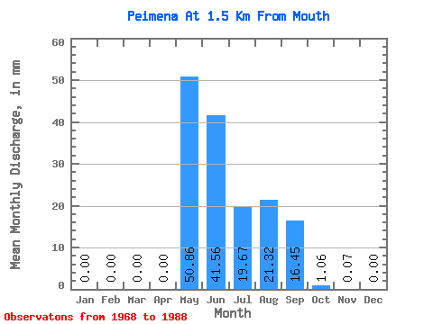
| Statistic | Jan | Feb | Mar | Apr | May | Jun | Jul | Aug | Sep | Oct | Nov | Dec | Annual |
|---|---|---|---|---|---|---|---|---|---|---|---|---|---|
| Mean | 0.00 | 0.00 | 0.00 | 0.00 | 50.86 | 41.56 | 19.66 | 21.32 | 16.45 | 1.06 | 0.07 | 0.00 | 136.94 |
| Standard Deviation | 0.00 | 0.00 | 0.00 | 0.00 | 24.68 | 30.30 | 19.99 | 16.98 | 13.77 | 1.10 | 0.09 | 0.00 | 61.18 |
| Min | 0.00 | 0.00 | 0.00 | 0.00 | 0.03 | 8.44 | 0.98 | 0.99 | 2.45 | 0.16 | 0.01 | 0.00 | 73.27 |
| Max | 0.00 | 0.00 | 0.00 | 0.00 | 105.85 | 119.27 | 74.91 | 74.37 | 49.56 | 4.47 | 0.39 | 0.00 | 195.29 |
| Coefficient of Variation | 0.48 | 0.73 | 1.02 | 0.80 | 0.84 | 1.03 | 1.25 | 2.00 | 0.45 |
 Return to R-Arctic Net Home Page