|
|
|||||||||||||||||
| Point ID: 5903 | Downloads | Plots | Site Data | Code: 1368 |
|
|
|||||||||||||||||
| Download | |
|---|---|
| Site Descriptor Information | Site Time Series Data |
| Link to all available data | |
| View: | Time Series | All |
| Units: | m3/s |
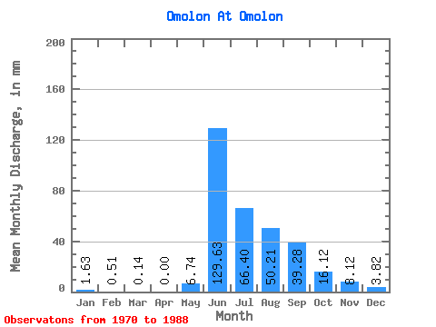
| Statistic | Jan | Feb | Mar | Apr | May | Jun | Jul | Aug | Sep | Oct | Nov | Dec | Annual |
|---|---|---|---|---|---|---|---|---|---|---|---|---|---|
| Mean | 1.63 | 0.52 | 0.14 | 0.00 | 6.74 | 129.63 | 66.39 | 50.20 | 39.28 | 16.12 | 8.12 | 3.82 | 345.72 |
| Standard Deviation | 1.09 | 0.45 | 0.11 | 0.00 | 8.98 | 34.77 | 28.39 | 18.09 | 17.77 | 3.12 | 2.21 | 1.99 | 16.33 |
| Min | 0.04 | 0.01 | 0.01 | 0.00 | 0.08 | 61.76 | 33.85 | 24.69 | 16.98 | 9.31 | 2.55 | 0.14 | 329.55 |
| Max | 3.58 | 1.38 | 0.32 | 0.00 | 26.85 | 199.81 | 130.65 | 90.95 | 86.63 | 23.17 | 11.11 | 6.86 | 362.21 |
| Coefficient of Variation | 0.67 | 0.88 | 0.78 | 1.33 | 0.27 | 0.43 | 0.36 | 0.45 | 0.19 | 0.27 | 0.52 | 0.05 |
 Return to R-Arctic Net Home Page