|
|
|||||||||||||||||
| Point ID: 5898 | Downloads | Plots | Site Data | Code: 1342 |
|
|
|||||||||||||||||
| Download | |
|---|---|
| Site Descriptor Information | Site Time Series Data |
| Link to all available data | |
| View: | Time Series | All |
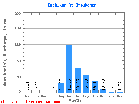
| Units: | m3/s |
| Statistic | Jan | Feb | Mar | Apr | May | Jun | Jul | Aug | Sep | Oct | Nov | Dec | Annual |
|---|---|---|---|---|---|---|---|---|---|---|---|---|---|
| Mean | 0.60 | 0.29 | 0.16 | 0.15 | 24.86 | 119.67 | 60.64 | 45.68 | 29.11 | 10.40 | 3.36 | 1.37 | 347.04 |
| Standard Deviation | 0.44 | 0.28 | 0.20 | 0.14 | 23.55 | 45.68 | 23.26 | 17.66 | 14.35 | 4.32 | 1.16 | 0.67 | 65.52 |
| Min | 0.10 | 0.01 | 0.00 | 0.00 | 0.07 | 46.11 | 29.89 | 15.03 | 11.20 | 4.22 | 1.45 | 0.51 | 260.68 |
| Max | 2.30 | 1.55 | 0.75 | 0.44 | 131.25 | 242.62 | 146.20 | 94.04 | 70.53 | 26.62 | 6.51 | 4.16 | 483.19 |
| Coefficient of Variation | 0.73 | 0.96 | 1.24 | 0.90 | 0.95 | 0.38 | 0.38 | 0.39 | 0.49 | 0.41 | 0.35 | 0.49 | 0.19 |
 Return to R-Arctic Net Home Page