|
|
|||||||||||||||||
| Point ID: 5896 | Downloads | Plots | Site Data | Code: 1314 |
|
|
|||||||||||||||||
| Download | |
|---|---|
| Site Descriptor Information | Site Time Series Data |
| Link to all available data | |
| View: | Time Series | All |
| Units: | m3/s |
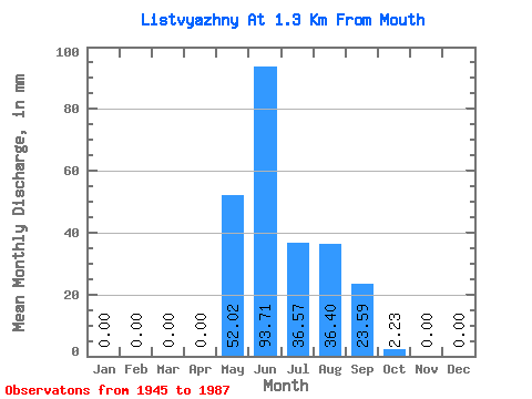
| Statistic | Jan | Feb | Mar | Apr | May | Jun | Jul | Aug | Sep | Oct | Nov | Dec | Annual |
|---|---|---|---|---|---|---|---|---|---|---|---|---|---|
| Mean | 0.00 | 0.00 | 0.00 | 0.00 | 51.94 | 93.71 | 36.61 | 36.35 | 23.53 | 2.25 | 0.00 | 0.00 | 245.89 |
| Standard Deviation | 0.00 | 0.00 | 0.00 | 0.00 | 27.92 | 62.44 | 30.92 | 23.88 | 17.58 | 1.51 | 0.00 | 0.00 | 13.23 |
| Min | 0.00 | 0.00 | 0.00 | 0.00 | 0.69 | 24.92 | 7.04 | 11.50 | 5.98 | 0.34 | 0.00 | 0.00 | 236.53 |
| Max | 0.00 | 0.00 | 0.00 | 0.00 | 118.45 | 247.57 | 147.63 | 120.17 | 96.37 | 6.01 | 0.00 | 0.00 | 255.25 |
| Coefficient of Variation | 0.54 | 0.67 | 0.84 | 0.66 | 0.75 | 0.67 | 0.05 |
 Return to R-Arctic Net Home Page