|
|
|||||||||||||||||
| Point ID: 5893 | Downloads | Plots | Site Data | Code: 1305 |
|
|
|||||||||||||||||
| Download | |
|---|---|
| Site Descriptor Information | Site Time Series Data |
| Link to all available data | |
| View: | Time Series | All |
| Units: | m3/s |
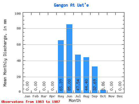
| Statistic | Jan | Feb | Mar | Apr | May | Jun | Jul | Aug | Sep | Oct | Nov | Dec | Annual |
|---|---|---|---|---|---|---|---|---|---|---|---|---|---|
| Mean | 0.00 | 0.00 | 0.00 | 0.00 | 65.46 | 84.91 | 47.52 | 44.30 | 32.67 | 3.81 | 0.00 | 0.00 | 379.93 |
| Standard Deviation | 0.00 | 0.00 | 0.00 | 0.00 | 36.28 | 58.35 | 28.28 | 19.68 | 23.25 | 3.82 | 0.00 | 0.00 | 31.33 |
| Min | 0.00 | 0.00 | 0.00 | 0.00 | 9.41 | 21.02 | 14.96 | 13.27 | 6.54 | 0.24 | 0.00 | 0.00 | 357.77 |
| Max | 0.00 | 0.00 | 0.00 | 0.00 | 149.58 | 221.84 | 123.04 | 84.44 | 86.40 | 14.48 | 0.00 | 0.00 | 402.08 |
| Coefficient of Variation | 0.55 | 0.69 | 0.59 | 0.44 | 0.71 | 1.00 | 0.08 |
 Return to R-Arctic Net Home Page