|
|
|||||||||||||||||
| Point ID: 5885 | Downloads | Plots | Site Data | Code: 1240 |
|
|
|||||||||||||||||
| Download | |
|---|---|
| Site Descriptor Information | Site Time Series Data |
| Link to all available data | |
| View: | Time Series | All |
| Units: | m3/s |
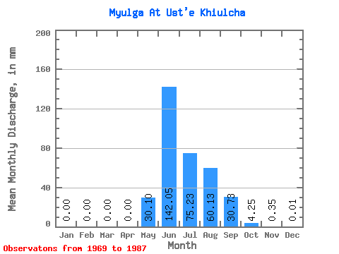
| Statistic | Jan | Feb | Mar | Apr | May | Jun | Jul | Aug | Sep | Oct | Nov | Dec | Annual |
|---|---|---|---|---|---|---|---|---|---|---|---|---|---|
| Mean | 0.00 | 0.00 | 0.00 | 0.00 | 30.10 | 142.05 | 75.22 | 60.12 | 30.73 | 4.25 | 0.34 | 0.01 | 368.43 |
| Standard Deviation | 0.00 | 0.00 | 0.00 | 0.00 | 20.28 | 56.98 | 39.44 | 25.08 | 15.97 | 1.70 | 0.34 | 0.01 | 0.28 |
| Min | 0.00 | 0.00 | 0.00 | 0.00 | 2.06 | 65.30 | 31.82 | 25.72 | 8.64 | 1.53 | 0.01 | 0.00 | 368.24 |
| Max | 0.00 | 0.00 | 0.00 | 0.00 | 66.88 | 275.17 | 173.53 | 116.08 | 59.31 | 7.66 | 1.17 | 0.03 | 368.63 |
| Coefficient of Variation | 0.67 | 0.40 | 0.52 | 0.42 | 0.52 | 0.40 | 0.98 | 1.25 | 0.00 |
 Return to R-Arctic Net Home Page