|
|
|||||||||||||||||
| Point ID: 5881 | Downloads | Plots | Site Data | Code: 1217 |
|
|
|||||||||||||||||
| Download | |
|---|---|
| Site Descriptor Information | Site Time Series Data |
| Link to all available data | |
| View: | Time Series | All |
| Units: | m3/s |
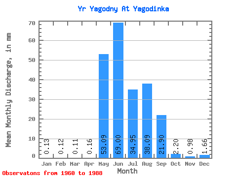
| Statistic | Jan | Feb | Mar | Apr | May | Jun | Jul | Aug | Sep | Oct | Nov | Dec | Annual |
|---|---|---|---|---|---|---|---|---|---|---|---|---|---|
| Mean | 0.14 | 0.12 | 0.12 | 0.16 | 53.08 | 69.00 | 34.96 | 38.08 | 21.91 | 2.20 | 0.99 | 1.66 | 192.68 |
| Standard Deviation | 0.75 | 0.63 | 0.65 | 0.52 | 28.82 | 46.95 | 24.77 | 25.10 | 16.33 | 2.07 | 1.92 | 2.50 | 95.40 |
| Min | 0.00 | 0.00 | 0.00 | 0.00 | 5.36 | 11.15 | 2.12 | 2.25 | 3.37 | 0.27 | 0.00 | 0.00 | 63.20 |
| Max | 4.02 | 3.42 | 3.48 | 2.15 | 135.78 | 208.14 | 100.42 | 85.96 | 58.58 | 8.57 | 5.44 | 5.62 | 279.60 |
| Coefficient of Variation | 5.38 | 5.38 | 5.38 | 3.19 | 0.54 | 0.68 | 0.71 | 0.66 | 0.74 | 0.94 | 1.93 | 1.51 | 0.49 |
 Return to R-Arctic Net Home Page