|
|
|||||||||||||||||
| Point ID: 5879 | Downloads | Plots | Site Data | Code: 1191 |
|
|
|||||||||||||||||
| Download | |
|---|---|
| Site Descriptor Information | Site Time Series Data |
| Link to all available data | |
| View: | Time Series | All |
| Units: | m3/s |
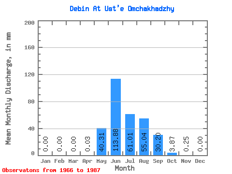
| Statistic | Jan | Feb | Mar | Apr | May | Jun | Jul | Aug | Sep | Oct | Nov | Dec | Annual |
|---|---|---|---|---|---|---|---|---|---|---|---|---|---|
| Mean | 0.00 | 0.00 | 0.00 | 0.03 | 40.30 | 113.88 | 61.00 | 55.03 | 30.20 | 3.87 | 0.25 | 0.00 | 352.39 |
| Standard Deviation | 0.00 | 0.00 | 0.00 | 0.04 | 27.34 | 51.13 | 29.89 | 26.15 | 16.01 | 1.85 | 0.35 | 0.01 | 10.34 |
| Min | 0.00 | 0.00 | 0.00 | 0.00 | 4.83 | 39.10 | 21.03 | 18.63 | 8.11 | 1.08 | 0.00 | 0.00 | 345.07 |
| Max | 0.00 | 0.00 | 0.00 | 0.08 | 101.81 | 236.85 | 129.28 | 114.97 | 64.35 | 7.87 | 1.32 | 0.01 | 359.70 |
| Coefficient of Variation | 1.73 | 0.68 | 0.45 | 0.49 | 0.47 | 0.53 | 0.48 | 1.40 | 1.73 | 0.03 |
 Return to R-Arctic Net Home Page