|
|
|||||||||||||||||
| Point ID: 5869 | Downloads | Plots | Site Data | Code: 1127 |
|
|
|||||||||||||||||
| Download | |
|---|---|
| Site Descriptor Information | Site Time Series Data |
| Link to all available data | |
| View: | Time Series | All |
| Units: | m3/s |
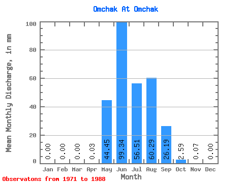
| Statistic | Jan | Feb | Mar | Apr | May | Jun | Jul | Aug | Sep | Oct | Nov | Dec | Annual |
|---|---|---|---|---|---|---|---|---|---|---|---|---|---|
| Mean | 0.00 | 0.00 | 0.00 | 0.03 | 44.45 | 99.33 | 56.51 | 60.29 | 26.19 | 2.59 | 0.08 | 0.00 | 327.10 |
| Standard Deviation | 0.00 | 0.00 | 0.00 | 0.05 | 39.02 | 72.28 | 21.57 | 35.68 | 18.67 | 1.50 | 0.12 | 0.00 | 111.69 |
| Min | 0.00 | 0.00 | 0.00 | 0.00 | 1.77 | 25.23 | 21.64 | 12.41 | 4.29 | 0.94 | 0.00 | 0.00 | 204.83 |
| Max | 0.00 | 0.00 | 0.00 | 0.12 | 156.60 | 291.81 | 99.14 | 131.06 | 72.44 | 5.85 | 0.34 | 0.00 | 423.76 |
| Coefficient of Variation | 1.54 | 0.88 | 0.73 | 0.38 | 0.59 | 0.71 | 0.58 | 1.52 | 0.34 |
 Return to R-Arctic Net Home Page