|
|
|||||||||||||||||
| Point ID: 585 | Downloads | Plots | Site Data | Code: 07AA004 |
|
|
|||||||||||||||||
| Download | |
|---|---|
| Site Descriptor Information | Site Time Series Data |
| Link to all available data | |
| View: | Time Series | All |
| Units: | m3/s |
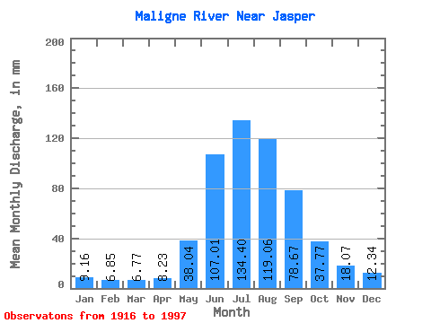
| Statistic | Jan | Feb | Mar | Apr | May | Jun | Jul | Aug | Sep | Oct | Nov | Dec | Annual |
|---|---|---|---|---|---|---|---|---|---|---|---|---|---|
| Mean | 9.16 | 6.91 | 6.77 | 8.23 | 38.04 | 107.00 | 134.38 | 119.05 | 78.67 | 37.77 | 18.07 | 12.34 | 561.47 |
| Standard Deviation | 1.05 | 0.72 | 0.81 | 1.97 | 16.22 | 13.85 | 30.08 | 28.91 | 28.47 | 10.69 | 3.26 | 1.50 | 84.23 |
| Min | 6.81 | 5.56 | 5.66 | 5.31 | 12.65 | 82.78 | 80.22 | 73.73 | 43.96 | 26.78 | 13.90 | 9.50 | 444.67 |
| Max | 11.30 | 8.28 | 8.94 | 12.16 | 79.34 | 131.60 | 199.08 | 220.91 | 125.32 | 61.05 | 24.61 | 15.13 | 796.04 |
| Coefficient of Variation | 0.12 | 0.10 | 0.12 | 0.24 | 0.43 | 0.13 | 0.22 | 0.24 | 0.36 | 0.28 | 0.18 | 0.12 | 0.15 |
 Return to R-Arctic Net Home Page