|
|
|||||||||||||||||
| Point ID: 5831 | Downloads | Plots | Site Data | Code: 09EC002 |
|
|
|||||||||||||||||
| Download | |
|---|---|
| Site Descriptor Information | Site Time Series Data |
| Link to all available data | |
| View: | Time Series | All |
| Units: | m3/s |
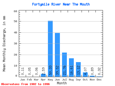
| Statistic | Jan | Feb | Mar | Apr | May | Jun | Jul | Aug | Sep | Oct | Nov | Dec | Annual |
|---|---|---|---|---|---|---|---|---|---|---|---|---|---|
| Mean | 0.11 | 0.05 | 0.06 | 2.59 | 50.32 | 39.52 | 21.75 | 16.61 | 13.12 | 4.07 | 0.89 | 0.32 | 142.64 |
| Standard Deviation | 0.08 | 0.05 | 0.07 | 4.14 | 23.82 | 21.71 | 10.81 | 10.18 | 8.29 | 2.34 | 0.48 | 0.17 | 42.59 |
| Min | 0.01 | 0.00 | 0.00 | 0.02 | 15.02 | 15.93 | 6.78 | 4.86 | 3.34 | 0.99 | 0.10 | 0.02 | 68.48 |
| Max | 0.27 | 0.17 | 0.26 | 11.76 | 107.44 | 78.70 | 40.81 | 40.49 | 31.70 | 8.86 | 1.87 | 0.55 | 206.77 |
| Coefficient of Variation | 0.73 | 1.17 | 1.27 | 1.60 | 0.47 | 0.55 | 0.50 | 0.61 | 0.63 | 0.58 | 0.54 | 0.54 | 0.30 |
 Return to R-Arctic Net Home Page