|
|
|||||||||||||||||
| Point ID: 5824 | Downloads | Plots | Site Data | Code: 09EA003 |
|
|
|||||||||||||||||
| Download | |
|---|---|
| Site Descriptor Information | Site Time Series Data |
| Link to all available data | |
| View: | Time Series | All |
| Units: | m3/s |
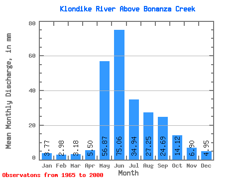
| Statistic | Jan | Feb | Mar | Apr | May | Jun | Jul | Aug | Sep | Oct | Nov | Dec | Annual |
|---|---|---|---|---|---|---|---|---|---|---|---|---|---|
| Mean | 3.77 | 3.00 | 3.18 | 5.50 | 56.86 | 75.06 | 34.94 | 27.25 | 24.69 | 14.12 | 6.90 | 4.95 | 257.65 |
| Standard Deviation | 0.79 | 0.56 | 0.69 | 3.24 | 14.86 | 21.80 | 14.55 | 10.59 | 9.28 | 4.52 | 1.61 | 1.30 | 50.14 |
| Min | 2.15 | 1.55 | 1.67 | 2.02 | 22.73 | 42.87 | 13.25 | 10.68 | 12.33 | 8.17 | 4.35 | 2.74 | 158.89 |
| Max | 6.80 | 4.29 | 4.43 | 15.05 | 83.43 | 134.25 | 78.62 | 48.41 | 52.17 | 23.83 | 10.50 | 9.03 | 394.61 |
| Coefficient of Variation | 0.21 | 0.19 | 0.22 | 0.59 | 0.26 | 0.29 | 0.42 | 0.39 | 0.38 | 0.32 | 0.23 | 0.26 | 0.20 |
 Return to R-Arctic Net Home Page