|
|
|||||||||||||||||
| Point ID: 5821 | Downloads | Plots | Site Data | Code: 09DD002 |
|
|
|||||||||||||||||
| Download | |
|---|---|
| Site Descriptor Information | Site Time Series Data |
| Link to all available data | |
| View: | Time Series | All |
| Units: | m3/s |
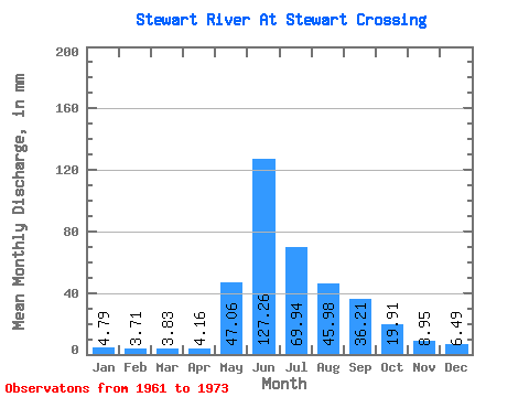
| Statistic | Jan | Feb | Mar | Apr | May | Jun | Jul | Aug | Sep | Oct | Nov | Dec | Annual |
|---|---|---|---|---|---|---|---|---|---|---|---|---|---|
| Mean | 4.79 | 3.74 | 3.83 | 4.16 | 47.06 | 127.26 | 69.93 | 45.97 | 36.21 | 19.91 | 8.95 | 6.49 | 373.55 |
| Standard Deviation | 0.91 | 0.73 | 0.83 | 0.81 | 15.89 | 42.64 | 18.92 | 12.47 | 7.51 | 4.59 | 1.67 | 0.98 | 74.37 |
| Min | 3.36 | 2.42 | 2.21 | 2.77 | 15.84 | 74.80 | 34.66 | 29.99 | 22.74 | 15.07 | 6.52 | 4.73 | 256.55 |
| Max | 6.39 | 4.87 | 5.22 | 5.92 | 65.27 | 233.28 | 114.77 | 75.98 | 51.10 | 31.07 | 11.40 | 7.88 | 546.43 |
| Coefficient of Variation | 0.19 | 0.20 | 0.22 | 0.19 | 0.34 | 0.34 | 0.27 | 0.27 | 0.21 | 0.23 | 0.19 | 0.15 | 0.20 |
 Return to R-Arctic Net Home Page