|
|
|||||||||||||||||
| Point ID: 5801 | Downloads | Plots | Site Data | Code: 09AH004 |
|
|
|||||||||||||||||
| Download | |
|---|---|
| Site Descriptor Information | Site Time Series Data |
| Link to all available data | |
| View: | Time Series | All |
| Units: | m3/s |
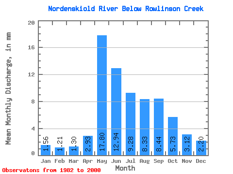
| Statistic | Jan | Feb | Mar | Apr | May | Jun | Jul | Aug | Sep | Oct | Nov | Dec | Annual |
|---|---|---|---|---|---|---|---|---|---|---|---|---|---|
| Mean | 1.56 | 1.22 | 1.30 | 2.93 | 17.80 | 12.94 | 9.28 | 8.33 | 8.44 | 5.73 | 3.12 | 2.20 | 74.53 |
| Standard Deviation | 0.76 | 0.51 | 0.51 | 1.91 | 6.57 | 7.37 | 5.62 | 6.25 | 7.59 | 3.95 | 1.78 | 1.12 | 33.03 |
| Min | 0.51 | 0.46 | 0.53 | 1.14 | 9.00 | 2.37 | 2.08 | 1.46 | 1.68 | 1.43 | 0.70 | 0.56 | 28.65 |
| Max | 3.58 | 2.59 | 2.57 | 8.30 | 30.02 | 32.27 | 23.80 | 26.82 | 34.55 | 17.49 | 6.75 | 4.58 | 140.71 |
| Coefficient of Variation | 0.49 | 0.42 | 0.40 | 0.65 | 0.37 | 0.57 | 0.60 | 0.75 | 0.90 | 0.69 | 0.57 | 0.51 | 0.44 |
 Return to R-Arctic Net Home Page