|
|
|||||||||||||||||
| Point ID: 5796 | Downloads | Plots | Site Data | Code: 09AF001 |
|
|
|||||||||||||||||
| Download | |
|---|---|
| Site Descriptor Information | Site Time Series Data |
| Link to all available data | |
| View: | Time Series | All |
| Units: | m3/s |
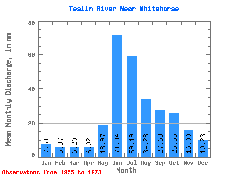
| Statistic | Jan | Feb | Mar | Apr | May | Jun | Jul | Aug | Sep | Oct | Nov | Dec | Annual |
|---|---|---|---|---|---|---|---|---|---|---|---|---|---|
| Mean | 7.51 | 5.92 | 6.20 | 6.02 | 18.97 | 71.84 | 59.19 | 34.27 | 27.69 | 25.55 | 16.00 | 10.22 | 285.82 |
| Standard Deviation | 2.49 | 1.59 | 1.34 | 1.23 | 5.50 | 17.25 | 16.61 | 7.12 | 8.82 | 8.12 | 4.42 | 2.88 | 37.24 |
| Min | 4.90 | 3.70 | 3.87 | 4.73 | 10.27 | 43.46 | 24.65 | 14.89 | 12.29 | 11.96 | 8.31 | 6.35 | 211.20 |
| Max | 14.67 | 10.29 | 9.17 | 8.45 | 30.16 | 100.13 | 102.72 | 46.00 | 51.84 | 37.49 | 22.72 | 17.39 | 351.63 |
| Coefficient of Variation | 0.33 | 0.27 | 0.22 | 0.20 | 0.29 | 0.24 | 0.28 | 0.21 | 0.32 | 0.32 | 0.28 | 0.28 | 0.13 |
 Return to R-Arctic Net Home Page