|
|
|||||||||||||||||
| Point ID: 5793 | Downloads | Plots | Site Data | Code: 09AD001 |
|
|
|||||||||||||||||
| Download | |
|---|---|
| Site Descriptor Information | Site Time Series Data |
| Link to all available data | |
| View: | Time Series | All |
| Units: | m3/s |
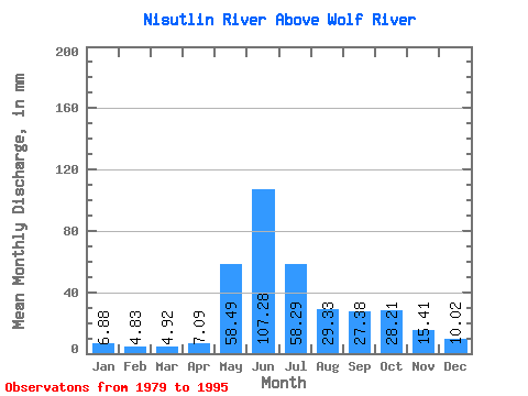
| Statistic | Jan | Feb | Mar | Apr | May | Jun | Jul | Aug | Sep | Oct | Nov | Dec | Annual |
|---|---|---|---|---|---|---|---|---|---|---|---|---|---|
| Mean | 6.88 | 4.87 | 4.92 | 7.09 | 58.48 | 107.28 | 58.28 | 29.33 | 27.38 | 28.21 | 15.41 | 10.02 | 357.31 |
| Standard Deviation | 1.80 | 0.91 | 0.92 | 2.93 | 20.53 | 30.65 | 24.71 | 8.29 | 9.47 | 9.27 | 6.41 | 4.08 | 72.42 |
| Min | 4.40 | 3.34 | 3.67 | 3.26 | 26.51 | 48.42 | 26.21 | 17.21 | 14.17 | 16.84 | 6.65 | 5.57 | 237.88 |
| Max | 10.87 | 6.59 | 7.17 | 12.07 | 99.72 | 180.44 | 109.05 | 48.02 | 55.84 | 45.69 | 27.02 | 21.51 | 514.24 |
| Coefficient of Variation | 0.26 | 0.19 | 0.19 | 0.41 | 0.35 | 0.29 | 0.42 | 0.28 | 0.35 | 0.33 | 0.42 | 0.41 | 0.20 |
 Return to R-Arctic Net Home Page