|
|
|||||||||||||||||
| Point ID: 5785 | Downloads | Plots | Site Data | Code: 09AA011 |
|
|
|||||||||||||||||
| Download | |
|---|---|
| Site Descriptor Information | Site Time Series Data |
| Link to all available data | |
| View: | Time Series | All |
| Units: | m3/s |
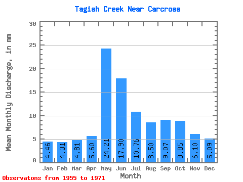
| Statistic | Jan | Feb | Mar | Apr | May | Jun | Jul | Aug | Sep | Oct | Nov | Dec | Annual |
|---|---|---|---|---|---|---|---|---|---|---|---|---|---|
| Mean | 4.45 | 4.33 | 4.81 | 5.60 | 24.20 | 17.89 | 10.75 | 8.48 | 9.07 | 8.84 | 6.08 | 5.07 | 120.35 |
| Standard Deviation | 1.16 | 1.11 | 1.57 | 1.87 | 8.61 | 7.34 | 4.00 | 3.02 | 3.46 | 2.77 | 1.84 | 1.34 | 17.68 |
| Min | 1.60 | 2.82 | 2.82 | 3.17 | 10.03 | 5.46 | 4.32 | 4.28 | 4.92 | 4.74 | 2.87 | 2.19 | 98.70 |
| Max | 5.71 | 6.12 | 7.91 | 9.20 | 33.47 | 31.79 | 17.31 | 14.49 | 15.64 | 12.57 | 9.88 | 7.17 | 142.79 |
| Coefficient of Variation | 0.26 | 0.26 | 0.33 | 0.33 | 0.36 | 0.41 | 0.37 | 0.36 | 0.38 | 0.31 | 0.30 | 0.26 | 0.15 |
 Return to R-Arctic Net Home Page