|
|
|||||||||||||||||
| Point ID: 578 | Downloads | Plots | Site Data | Code: 06AD006 |
|
|
|||||||||||||||||
| Download | |
|---|---|
| Site Descriptor Information | Site Time Series Data |
| Link to all available data | |
| View: | Time Series | All |
| Units: | m3/s |
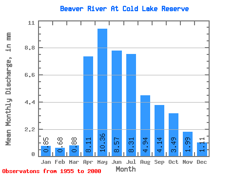
| Statistic | Jan | Feb | Mar | Apr | May | Jun | Jul | Aug | Sep | Oct | Nov | Dec | Annual |
|---|---|---|---|---|---|---|---|---|---|---|---|---|---|
| Mean | 0.68 | 0.55 | 0.71 | 6.49 | 8.28 | 6.85 | 6.64 | 3.95 | 3.31 | 2.79 | 1.59 | 0.89 | 42.67 |
| Standard Deviation | 0.51 | 0.38 | 0.43 | 5.72 | 8.24 | 8.93 | 7.84 | 4.06 | 3.17 | 2.48 | 1.44 | 0.78 | 32.47 |
| Min | 0.09 | 0.07 | 0.13 | 0.91 | 0.61 | 0.48 | 0.34 | 0.19 | 0.19 | 0.18 | 0.13 | 0.14 | 4.40 |
| Max | 2.18 | 1.65 | 1.79 | 27.53 | 45.80 | 50.77 | 30.29 | 17.91 | 13.91 | 9.92 | 6.10 | 3.29 | 132.10 |
| Coefficient of Variation | 0.75 | 0.69 | 0.60 | 0.88 | 0.99 | 1.30 | 1.18 | 1.03 | 0.96 | 0.89 | 0.90 | 0.87 | 0.76 |
 Return to R-Arctic Net Home Page