|
|
|||||||||||||||||
| Point ID: 577 | Downloads | Plots | Site Data | Code: 06AC901 |
|
|
|||||||||||||||||
| Download | |
|---|---|
| Site Descriptor Information | Site Time Series Data |
| Link to all available data | |
| View: | Time Series | All |
| Units: | m3/s |
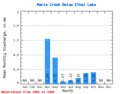
| Statistic | Jan | Feb | Mar | Apr | May | Jun | Jul | Aug | Sep | Oct | Nov | Dec | Annual |
|---|---|---|---|---|---|---|---|---|---|---|---|---|---|
| Mean | 1.24 | 0.72 | 0.07 | 0.10 | 0.16 | 0.30 | 0.32 | ||||||
| Standard Deviation | 1.76 | 1.02 | 0.10 | 0.10 | 0.15 | 0.42 | |||||||
| Min | 0.00 | 0.00 | 0.00 | 0.03 | 0.05 | 0.00 | 0.32 | ||||||
| Max | 2.48 | 1.45 | 0.14 | 0.17 | 0.26 | 0.61 | 0.32 | ||||||
| Coefficient of Variation | 1.41 | 1.41 | 1.33 | 1.03 | 0.93 | 1.39 |
 Return to R-Arctic Net Home Page