|
|
|||||||||||||||||
| Point ID: 562 | Downloads | Plots | Site Data | Code: 05GA009 |
|
|
|||||||||||||||||
| Download | |
|---|---|
| Site Descriptor Information | Site Time Series Data |
| Link to all available data | |
| View: | Time Series | All |
| Units: | m3/s |
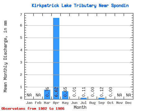
| Statistic | Jan | Feb | Mar | Apr | May | Jun | Jul | Aug | Sep | Oct | Nov | Dec | Annual |
|---|---|---|---|---|---|---|---|---|---|---|---|---|---|
| Mean | 0.73 | 6.29 | 0.61 | 0.01 | 0.11 | 0.00 | 0.11 | 0.01 | |||||
| Standard Deviation | 1.10 | 12.39 | 1.22 | 0.02 | 0.25 | 0.00 | 0.26 | 0.01 | |||||
| Min | 0.00 | 0.00 | 0.00 | 0.00 | 0.00 | 0.00 | 0.00 | 0.00 | |||||
| Max | 2.32 | 24.87 | 2.45 | 0.04 | 0.57 | 0.00 | 0.57 | 0.02 | |||||
| Coefficient of Variation | 1.51 | 1.97 | 2.00 | 2.24 | 2.24 | 2.24 | 2.24 |
 Return to R-Arctic Net Home Page