|
|
|||||||||||||||||
| Point ID: 5617 | Downloads | Plots | Site Data | Code: 07LE004 |
|
|
|||||||||||||||||
| Download | |
|---|---|
| Site Descriptor Information | Site Time Series Data |
| Link to all available data | |
| View: | Time Series | All |
| Units: | m3/s |
| Statistic | Jan | Feb | Mar | Apr | May | Jun | Jul | Aug | Sep | Oct | Nov | Dec | Annual |
|---|---|---|---|---|---|---|---|---|---|---|---|---|---|
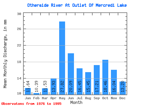
| Mean | 11.64 | 10.48 | 11.52 | 13.93 | 27.82 | 20.09 | 16.45 | 15.45 | 17.21 | 18.45 | 16.04 | 13.20 | 192.21 |
| Standard Deviation | 2.52 | 2.41 | 2.50 | 3.14 | 7.88 | 5.60 | 3.84 | 4.68 | 5.32 | 5.20 | 4.01 | 3.29 | 38.27 |
| Min | 4.87 | 4.04 | 4.66 | 6.61 | 14.28 | 10.27 | 9.39 | 8.07 | 6.86 | 8.84 | 9.49 | 7.34 | 125.12 |
| Max | 15.28 | 13.92 | 14.88 | 20.45 | 46.42 | 34.27 | 23.21 | 27.67 | 25.73 | 33.13 | 26.40 | 19.24 | 257.16 |
| Coefficient of Variation | 0.22 | 0.23 | 0.22 | 0.23 | 0.28 | 0.28 | 0.23 | 0.30 | 0.31 | 0.28 | 0.25 | 0.25 | 0.20 |
 Return to R-Arctic Net Home Page