|
|
|||||||||||||||||
| Point ID: 5609 | Downloads | Plots | Site Data | Code: 07LB002 |
|
|
|||||||||||||||||
| Download | |
|---|---|
| Site Descriptor Information | Site Time Series Data |
| Link to all available data | |
| View: | Time Series | All |
| Units: | m3/s |
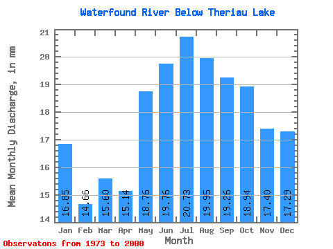
| Statistic | Jan | Feb | Mar | Apr | May | Jun | Jul | Aug | Sep | Oct | Nov | Dec | Annual |
|---|---|---|---|---|---|---|---|---|---|---|---|---|---|
| Mean | 16.85 | 14.78 | 15.60 | 15.14 | 18.76 | 19.75 | 20.72 | 19.95 | 19.26 | 18.94 | 17.40 | 17.28 | 213.16 |
| Standard Deviation | 3.45 | 2.83 | 2.67 | 2.38 | 3.05 | 3.51 | 3.97 | 3.73 | 4.87 | 5.20 | 4.62 | 4.01 | 29.49 |
| Min | 9.75 | 8.88 | 9.83 | 9.93 | 13.98 | 14.27 | 15.09 | 13.56 | 12.06 | 11.10 | 9.68 | 10.25 | 172.45 |
| Max | 25.76 | 22.32 | 22.80 | 20.92 | 24.92 | 27.23 | 31.19 | 30.76 | 32.97 | 30.42 | 28.79 | 28.14 | 268.24 |
| Coefficient of Variation | 0.20 | 0.19 | 0.17 | 0.16 | 0.16 | 0.18 | 0.19 | 0.19 | 0.25 | 0.27 | 0.27 | 0.23 | 0.14 |
 Return to R-Arctic Net Home Page