|
|
|||||||||||||||||
| Point ID: 5608 | Downloads | Plots | Site Data | Code: 07CD007 |
|
|
|||||||||||||||||
| Download | |
|---|---|
| Site Descriptor Information | Site Time Series Data |
| Link to all available data | |
| View: | Time Series | All |
| Units: | m3/s |
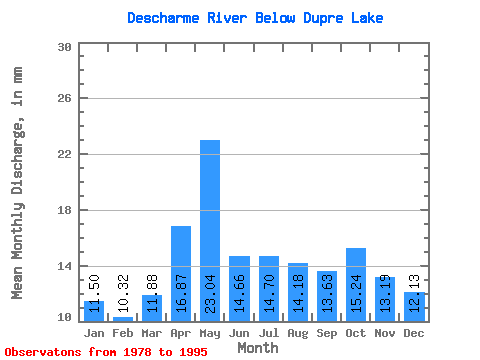
| Statistic | Jan | Feb | Mar | Apr | May | Jun | Jul | Aug | Sep | Oct | Nov | Dec | Annual |
|---|---|---|---|---|---|---|---|---|---|---|---|---|---|
| Mean | 11.50 | 10.40 | 11.87 | 16.87 | 23.03 | 14.66 | 14.70 | 14.18 | 13.63 | 15.24 | 13.19 | 12.12 | 168.71 |
| Standard Deviation | 1.29 | 0.91 | 1.10 | 2.57 | 5.00 | 2.31 | 3.11 | 2.46 | 2.04 | 3.01 | 1.82 | 1.18 | 12.52 |
| Min | 9.18 | 7.97 | 9.94 | 11.82 | 15.81 | 11.47 | 9.60 | 10.22 | 11.12 | 11.11 | 9.59 | 9.84 | 157.15 |
| Max | 13.36 | 11.78 | 13.83 | 22.70 | 37.24 | 20.40 | 20.28 | 17.75 | 18.10 | 22.98 | 17.02 | 14.13 | 204.33 |
| Coefficient of Variation | 0.11 | 0.09 | 0.09 | 0.15 | 0.22 | 0.16 | 0.21 | 0.17 | 0.15 | 0.20 | 0.14 | 0.10 | 0.07 |
 Return to R-Arctic Net Home Page