|
|
|||||||||||||||||
| Point ID: 56 | Downloads | Plots | Site Data | Code: 05AC002 |
|
|
|||||||||||||||||
| Download | |
|---|---|
| Site Descriptor Information | Site Time Series Data |
| Link to all available data | |
| View: | Time Series | All |
| Units: | m3/s |
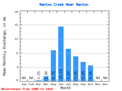
| Statistic | Jan | Feb | Mar | Apr | May | Jun | Jul | Aug | Sep | Oct | Nov | Dec | Annual |
|---|---|---|---|---|---|---|---|---|---|---|---|---|---|
| Mean | 0.24 | 1.37 | 8.75 | 15.54 | 9.23 | 7.05 | 5.49 | 4.46 | |||||
| Standard Deviation | 0.61 | 10.23 | 20.22 | 14.01 | 7.88 | 7.28 | 4.92 | ||||||
| Min | 0.24 | 0.39 | 0.69 | 0.04 | 0.00 | 0.00 | 0.00 | 0.02 | |||||
| Max | 0.24 | 2.05 | 26.11 | 50.11 | 42.85 | 18.93 | 24.84 | 17.81 | |||||
| Coefficient of Variation | 0.44 | 1.17 | 1.30 | 1.52 | 1.12 | 1.32 | 1.10 |
 Return to R-Arctic Net Home Page