|
|
|||||||||||||||||
| Point ID: 5598 | Downloads | Plots | Site Data | Code: 06DB003 |
|
|
|||||||||||||||||
| Download | |
|---|---|
| Site Descriptor Information | Site Time Series Data |
| Link to all available data | |
| View: | Time Series | All |
| Units: | m3/s |
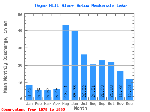
| Statistic | Jan | Feb | Mar | Apr | May | Jun | Jul | Aug | Sep | Oct | Nov | Dec | Annual |
|---|---|---|---|---|---|---|---|---|---|---|---|---|---|
| Mean | 8.43 | 5.95 | 5.63 | 6.45 | 43.10 | 39.73 | 26.32 | 20.51 | 22.93 | 21.88 | 16.72 | 12.23 | 232.47 |
| Standard Deviation | 2.04 | 1.45 | 1.34 | 3.29 | 24.10 | 17.72 | 11.41 | 9.84 | 17.87 | 13.45 | 6.80 | 3.61 | 61.74 |
| Min | 4.94 | 3.44 | 3.25 | 3.03 | 12.30 | 11.30 | 9.81 | 7.29 | 5.20 | 5.23 | 6.36 | 6.74 | 150.98 |
| Max | 11.29 | 8.03 | 8.53 | 17.75 | 93.11 | 73.57 | 52.32 | 41.41 | 78.96 | 53.15 | 30.70 | 19.26 | 329.58 |
| Coefficient of Variation | 0.24 | 0.24 | 0.24 | 0.51 | 0.56 | 0.45 | 0.43 | 0.48 | 0.78 | 0.61 | 0.41 | 0.29 | 0.27 |
 Return to R-Arctic Net Home Page