|
|
|||||||||||||||||
| Point ID: 5596 | Downloads | Plots | Site Data | Code: 06DA005 |
|
|
|||||||||||||||||
| Download | |
|---|---|
| Site Descriptor Information | Site Time Series Data |
| Link to all available data | |
| View: | Time Series | All |
| Units: | m3/s |
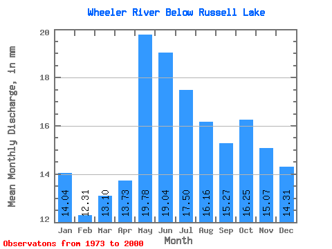
| Statistic | Jan | Feb | Mar | Apr | May | Jun | Jul | Aug | Sep | Oct | Nov | Dec | Annual |
|---|---|---|---|---|---|---|---|---|---|---|---|---|---|
| Mean | 14.04 | 12.42 | 13.10 | 13.73 | 19.78 | 19.04 | 17.49 | 16.16 | 15.27 | 16.25 | 15.07 | 14.31 | 182.04 |
| Standard Deviation | 4.32 | 4.03 | 3.52 | 2.68 | 3.10 | 4.13 | 4.57 | 5.14 | 6.11 | 6.37 | 4.91 | 4.07 | 39.54 |
| Min | 8.84 | 6.87 | 7.34 | 8.81 | 15.03 | 11.29 | 10.96 | 8.75 | 7.64 | 8.34 | 8.90 | 8.93 | 130.80 |
| Max | 24.04 | 22.63 | 21.83 | 20.27 | 27.22 | 30.37 | 31.02 | 30.76 | 33.96 | 32.70 | 28.49 | 25.01 | 287.82 |
| Coefficient of Variation | 0.31 | 0.33 | 0.27 | 0.20 | 0.16 | 0.22 | 0.26 | 0.32 | 0.40 | 0.39 | 0.33 | 0.28 | 0.22 |
 Return to R-Arctic Net Home Page