|
|
|||||||||||||||||
| Point ID: 5593 | Downloads | Plots | Site Data | Code: 06CD004 |
|
|
|||||||||||||||||
| Download | |
|---|---|
| Site Descriptor Information | Site Time Series Data |
| Link to all available data | |
| View: | Time Series | All |
| Units: | m3/s |
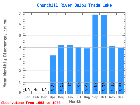
| Statistic | Jan | Feb | Mar | Apr | May | Jun | Jul | Aug | Sep | Oct | Nov | Dec | Annual |
|---|---|---|---|---|---|---|---|---|---|---|---|---|---|
| Mean | 3.15 | 4.00 | 3.96 | 3.85 | 3.71 | 6.48 | 6.45 | 3.90 | 3.73 | ||||
| Standard Deviation | 0.30 | 0.76 | 0.36 | 0.41 | 5.02 | 4.13 | 0.72 | 0.22 | |||||
| Min | 3.15 | 3.79 | 3.42 | 3.60 | 3.42 | 3.18 | 3.44 | 3.39 | 3.58 | ||||
| Max | 3.15 | 4.21 | 4.50 | 4.11 | 4.00 | 12.26 | 11.15 | 4.41 | 3.88 | ||||
| Coefficient of Variation | 0.07 | 0.19 | 0.10 | 0.11 | 0.78 | 0.64 | 0.18 | 0.06 |
 Return to R-Arctic Net Home Page