|
|
|||||||||||||||||
| Point ID: 5581 | Downloads | Plots | Site Data | Code: 06BB003 |
|
|
|||||||||||||||||
| Download | |
|---|---|
| Site Descriptor Information | Site Time Series Data |
| Link to all available data | |
| View: | Time Series | All |
| Units: | m3/s |
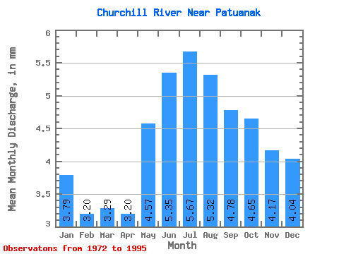
| Statistic | Jan | Feb | Mar | Apr | May | Jun | Jul | Aug | Sep | Oct | Nov | Dec | Annual |
|---|---|---|---|---|---|---|---|---|---|---|---|---|---|
| Mean | 3.48 | 2.96 | 3.02 | 2.94 | 4.19 | 4.91 | 5.21 | 4.88 | 4.38 | 4.27 | 3.83 | 3.71 | 48.08 |
| Standard Deviation | 2.00 | 1.62 | 1.55 | 1.40 | 2.89 | 3.66 | 3.76 | 3.44 | 3.19 | 3.07 | 2.54 | 2.29 | 30.14 |
| Min | 0.81 | 0.75 | 0.86 | 0.87 | 0.95 | 0.83 | 0.86 | 0.86 | 0.84 | 0.84 | 0.82 | 0.83 | 10.29 |
| Max | 8.61 | 6.88 | 6.57 | 6.32 | 15.24 | 19.00 | 19.36 | 17.05 | 15.31 | 14.60 | 11.76 | 10.34 | 149.18 |
| Coefficient of Variation | 0.57 | 0.55 | 0.52 | 0.48 | 0.69 | 0.74 | 0.72 | 0.70 | 0.73 | 0.72 | 0.66 | 0.62 | 0.63 |
 Return to R-Arctic Net Home Page