|
|
|||||||||||||||||
| Point ID: 5566 | Downloads | Plots | Site Data | Code: 06AD004 |
|
|
|||||||||||||||||
| Download | |
|---|---|
| Site Descriptor Information | Site Time Series Data |
| Link to all available data | |
| View: | Time Series | All |
| Units: | m3/s |
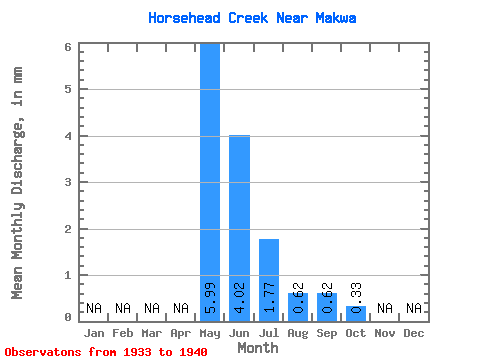
| Statistic | Jan | Feb | Mar | Apr | May | Jun | Jul | Aug | Sep | Oct | Nov | Dec | Annual |
|---|---|---|---|---|---|---|---|---|---|---|---|---|---|
| Mean | 5.25 | 3.53 | 1.56 | 0.55 | 0.54 | 0.28 | |||||||
| Standard Deviation | 4.80 | 5.79 | 1.92 | 0.84 | 1.09 | 0.22 | |||||||
| Min | 0.92 | 0.46 | 0.18 | 0.04 | 0.00 | 0.00 | |||||||
| Max | 15.63 | 17.53 | 5.38 | 2.60 | 3.21 | 0.59 | |||||||
| Coefficient of Variation | 0.92 | 1.64 | 1.23 | 1.54 | 2.02 | 0.78 |
 Return to R-Arctic Net Home Page