|
|
|||||||||||||||||
| Point ID: 5550 | Downloads | Plots | Site Data | Code: 05NC004 |
|
|
|||||||||||||||||
| Download | |
|---|---|
| Site Descriptor Information | Site Time Series Data |
| Link to all available data | |
| View: | Time Series | All |
| Units: | m3/s |
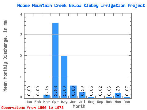
| Statistic | Jan | Feb | Mar | Apr | May | Jun | Jul | Aug | Sep | Oct | Nov | Dec | Annual |
|---|---|---|---|---|---|---|---|---|---|---|---|---|---|
| Mean | 0.00 | 0.00 | 0.05 | 1.21 | 0.68 | 0.20 | 0.10 | 0.02 | 0.01 | 0.02 | 0.08 | 0.02 | 5.24 |
| Standard Deviation | 0.00 | 0.00 | 0.16 | 1.85 | 0.98 | 0.28 | 0.12 | 0.03 | 0.02 | 0.06 | 0.10 | 0.04 | 1.77 |
| Min | 0.00 | 0.00 | 0.00 | 0.00 | 0.00 | 0.00 | 0.00 | 0.00 | 0.00 | 0.00 | 0.00 | 0.00 | 3.99 |
| Max | 0.00 | 0.00 | 0.61 | 6.24 | 3.52 | 1.01 | 0.33 | 0.08 | 0.08 | 0.24 | 0.19 | 0.06 | 6.50 |
| Coefficient of Variation | 3.02 | 1.53 | 1.44 | 1.34 | 1.20 | 1.44 | 2.94 | 2.89 | 1.22 | 1.52 | 0.34 |
 Return to R-Arctic Net Home Page