|
|
|||||||||||||||||
| Point ID: 5546 | Downloads | Plots | Site Data | Code: 05NB036 |
|
|
|||||||||||||||||
| Download | |
|---|---|
| Site Descriptor Information | Site Time Series Data |
| Link to all available data | |
| View: | Time Series | All |
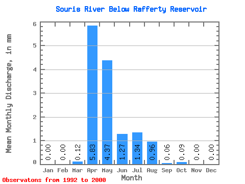
| Units: | m3/s |
| Statistic | Jan | Feb | Mar | Apr | May | Jun | Jul | Aug | Sep | Oct | Nov | Dec | Annual |
|---|---|---|---|---|---|---|---|---|---|---|---|---|---|
| Mean | 0.00 | 0.00 | 0.05 | 2.36 | 1.77 | 0.52 | 0.54 | 0.39 | 0.03 | 0.04 | 0.00 | 0.00 | 5.68 |
| Standard Deviation | 0.00 | 0.00 | 0.12 | 6.67 | 3.26 | 0.82 | 1.21 | 1.14 | 0.06 | 0.11 | 0.00 | 0.00 | 12.60 |
| Min | 0.00 | 0.00 | 0.00 | 0.00 | 0.00 | 0.00 | 0.00 | 0.00 | 0.00 | 0.00 | 0.00 | 0.00 | 0.00 |
| Max | 0.00 | 0.00 | 0.36 | 20.11 | 9.29 | 2.14 | 3.56 | 3.43 | 0.17 | 0.32 | 0.00 | 0.00 | 38.45 |
| Coefficient of Variation | 2.28 | 2.28 | 2.55 | 2.83 | 1.84 | 1.60 | 2.23 | 2.94 | 2.19 | 2.91 | 1.36 | 1.67 | 2.22 |
 Return to R-Arctic Net Home Page