|
|
|||||||||||||||||
| Point ID: 5541 | Downloads | Plots | Site Data | Code: 05NB030 |
|
|
|||||||||||||||||
| Download | |
|---|---|
| Site Descriptor Information | Site Time Series Data |
| Link to all available data | |
| View: | Time Series | All |
| Units: | m3/s |
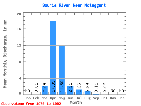
| Statistic | Jan | Feb | Mar | Apr | May | Jun | Jul | Aug | Sep | Oct | Nov | Dec | Annual |
|---|---|---|---|---|---|---|---|---|---|---|---|---|---|
| Mean | 0.00 | 0.56 | 4.75 | 3.14 | 0.59 | 0.34 | 0.24 | 0.03 | 0.01 | ||||
| Standard Deviation | 0.00 | 1.06 | 8.78 | 5.63 | 1.69 | 0.67 | 0.57 | 0.09 | 0.02 | ||||
| Min | 0.00 | 0.00 | 0.00 | 0.00 | 0.00 | 0.00 | 0.00 | 0.00 | 0.00 | ||||
| Max | 0.00 | 3.42 | 34.53 | 22.72 | 7.11 | 2.44 | 2.27 | 0.39 | 0.07 | ||||
| Coefficient of Variation | 1.41 | 1.90 | 1.85 | 1.79 | 2.87 | 2.00 | 2.41 | 3.07 | 3.11 |
 Return to R-Arctic Net Home Page