|
|
|||||||||||||||||
| Point ID: 554 | Downloads | Plots | Site Data | Code: 05FD005 |
|
|
|||||||||||||||||
| Download | |
|---|---|
| Site Descriptor Information | Site Time Series Data |
| Link to all available data | |
| View: | Time Series | All |
| Units: | m3/s |
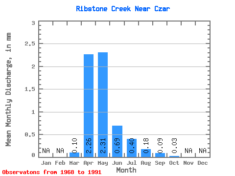
| Statistic | Jan | Feb | Mar | Apr | May | Jun | Jul | Aug | Sep | Oct | Nov | Dec | Annual |
|---|---|---|---|---|---|---|---|---|---|---|---|---|---|
| Mean | 0.04 | 0.86 | 0.88 | 0.26 | 0.15 | 0.07 | 0.04 | 0.01 | |||||
| Standard Deviation | 0.05 | 1.46 | 1.96 | 0.49 | 0.26 | 0.12 | 0.09 | 0.02 | |||||
| Min | 0.00 | 0.00 | 0.00 | 0.00 | 0.00 | 0.00 | 0.00 | 0.00 | |||||
| Max | 0.18 | 4.45 | 9.00 | 2.11 | 1.00 | 0.48 | 0.41 | 0.08 | |||||
| Coefficient of Variation | 1.31 | 1.70 | 2.24 | 1.89 | 1.69 | 1.73 | 2.56 | 2.18 |
 Return to R-Arctic Net Home Page