|
|
|||||||||||||||||
| Point ID: 5537 | Downloads | Plots | Site Data | Code: 05NB025 |
|
|
|||||||||||||||||
| Download | |
|---|---|
| Site Descriptor Information | Site Time Series Data |
| Link to all available data | |
| View: | Time Series | All |
| Units: | m3/s |
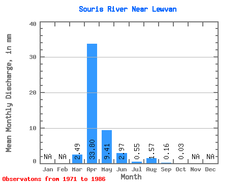
| Statistic | Jan | Feb | Mar | Apr | May | Jun | Jul | Aug | Sep | Oct | Nov | Dec | Annual |
|---|---|---|---|---|---|---|---|---|---|---|---|---|---|
| Mean | 0.84 | 11.46 | 3.19 | 1.00 | 0.19 | 0.53 | 0.05 | 0.01 | |||||
| Standard Deviation | 1.81 | 15.15 | 5.90 | 2.12 | 0.39 | 1.62 | 0.14 | 0.03 | |||||
| Min | 0.00 | 0.00 | 0.00 | 0.00 | 0.00 | 0.00 | 0.00 | 0.00 | |||||
| Max | 5.95 | 53.16 | 22.79 | 8.04 | 1.50 | 6.36 | 0.48 | 0.10 | |||||
| Coefficient of Variation | 2.14 | 1.32 | 1.85 | 2.12 | 2.08 | 3.04 | 2.64 | 2.62 |
 Return to R-Arctic Net Home Page