|
|
|||||||||||||||||
| Point ID: 5533 | Downloads | Plots | Site Data | Code: 05NB018 |
|
|
|||||||||||||||||
| Download | |
|---|---|
| Site Descriptor Information | Site Time Series Data |
| Link to all available data | |
| View: | Time Series | All |
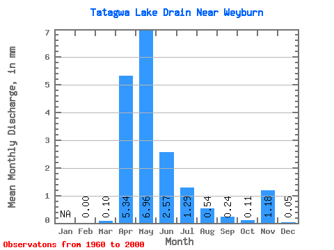
| Units: | m3/s |
| Statistic | Jan | Feb | Mar | Apr | May | Jun | Jul | Aug | Sep | Oct | Nov | Dec | Annual |
|---|---|---|---|---|---|---|---|---|---|---|---|---|---|
| Mean | 0.00 | 0.07 | 4.34 | 5.66 | 2.08 | 1.05 | 0.43 | 0.19 | 0.09 | 0.96 | 0.04 | ||
| Standard Deviation | 0.21 | 7.94 | 10.65 | 4.86 | 2.38 | 1.01 | 0.42 | 0.22 | 0.56 | 0.06 | |||
| Min | 0.00 | 0.00 | 0.00 | 0.00 | 0.00 | 0.00 | 0.00 | 0.00 | 0.00 | 0.56 | 0.00 | ||
| Max | 0.00 | 1.24 | 36.83 | 43.29 | 22.25 | 9.80 | 4.40 | 1.52 | 0.98 | 1.35 | 0.08 | ||
| Coefficient of Variation | 2.89 | 1.83 | 1.88 | 2.34 | 2.26 | 2.34 | 2.21 | 2.40 | 0.58 | 1.41 |
 Return to R-Arctic Net Home Page