|
|
|||||||||||||||||
| Point ID: 5530 | Downloads | Plots | Site Data | Code: 05NB014 |
|
|
|||||||||||||||||
| Download | |
|---|---|
| Site Descriptor Information | Site Time Series Data |
| Link to all available data | |
| View: | Time Series | All |
| Units: | m3/s |
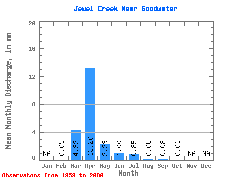
| Statistic | Jan | Feb | Mar | Apr | May | Jun | Jul | Aug | Sep | Oct | Nov | Dec | Annual |
|---|---|---|---|---|---|---|---|---|---|---|---|---|---|
| Mean | 0.05 | 3.97 | 12.13 | 2.10 | 0.92 | 0.78 | 0.08 | 0.07 | 0.02 | ||||
| Standard Deviation | 0.07 | 8.22 | 19.82 | 5.84 | 2.60 | 3.84 | 0.46 | 0.30 | 0.08 | ||||
| Min | 0.00 | 0.00 | 0.00 | 0.00 | 0.00 | 0.00 | 0.00 | 0.00 | 0.00 | ||||
| Max | 0.10 | 36.13 | 75.03 | 30.62 | 14.26 | 24.73 | 3.00 | 1.75 | 0.46 | ||||
| Coefficient of Variation | 1.41 | 2.07 | 1.63 | 2.78 | 2.84 | 4.91 | 5.69 | 4.14 | 4.73 |
 Return to R-Arctic Net Home Page