|
|
|||||||||||||||||
| Point ID: 5526 | Downloads | Plots | Site Data | Code: 05NB009 |
|
|
|||||||||||||||||
| Download | |
|---|---|
| Site Descriptor Information | Site Time Series Data |
| Link to all available data | |
| View: | Time Series | All |
| Units: | m3/s |
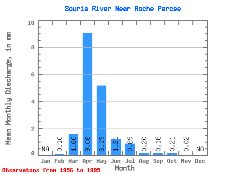
| Statistic | Jan | Feb | Mar | Apr | May | Jun | Jul | Aug | Sep | Oct | Nov | Dec | Annual |
|---|---|---|---|---|---|---|---|---|---|---|---|---|---|
| Mean | 0.03 | 0.57 | 3.23 | 1.84 | 0.43 | 0.32 | 0.07 | 0.06 | 0.07 | 0.01 | |||
| Standard Deviation | 0.06 | 1.16 | 5.76 | 3.90 | 0.98 | 0.68 | 0.12 | 0.14 | 0.14 | ||||
| Min | 0.00 | 0.00 | 0.01 | 0.00 | 0.00 | 0.00 | 0.00 | 0.00 | 0.00 | 0.01 | |||
| Max | 0.13 | 5.17 | 26.94 | 16.57 | 5.22 | 3.54 | 0.43 | 0.64 | 0.65 | 0.01 | |||
| Coefficient of Variation | 1.86 | 2.03 | 1.78 | 2.12 | 2.26 | 2.14 | 1.63 | 2.19 | 1.92 |
 Return to R-Arctic Net Home Page