|
|
|||||||||||||||||
| Point ID: 5511 | Downloads | Plots | Site Data | Code: 05MC004 |
|
|
|||||||||||||||||
| Download | |
|---|---|
| Site Descriptor Information | Site Time Series Data |
| Link to all available data | |
| View: | Time Series | All |
| Units: | m3/s |
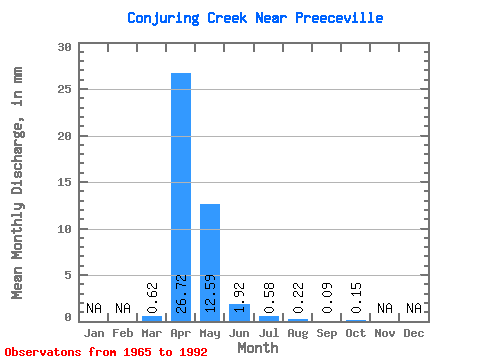
| Statistic | Jan | Feb | Mar | Apr | May | Jun | Jul | Aug | Sep | Oct | Nov | Dec | Annual |
|---|---|---|---|---|---|---|---|---|---|---|---|---|---|
| Mean | 0.35 | 14.98 | 7.06 | 1.08 | 0.32 | 0.13 | 0.05 | 0.09 | |||||
| Standard Deviation | 0.71 | 11.39 | 11.71 | 2.21 | 0.70 | 0.20 | 0.02 | 0.06 | |||||
| Min | 0.00 | 0.09 | 0.00 | 0.03 | 0.01 | 0.01 | 0.01 | 0.01 | |||||
| Max | 2.18 | 38.93 | 43.69 | 9.48 | 2.62 | 0.83 | 0.10 | 0.30 | |||||
| Coefficient of Variation | 2.02 | 0.76 | 1.66 | 2.04 | 2.16 | 1.54 | 0.45 | 0.76 |
 Return to R-Arctic Net Home Page