|
|
|||||||||||||||||
| Point ID: 550 | Downloads | Plots | Site Data | Code: 05FC007 |
|
|
|||||||||||||||||
| Download | |
|---|---|
| Site Descriptor Information | Site Time Series Data |
| Link to all available data | |
| View: | Time Series | All |
| Units: | m3/s |
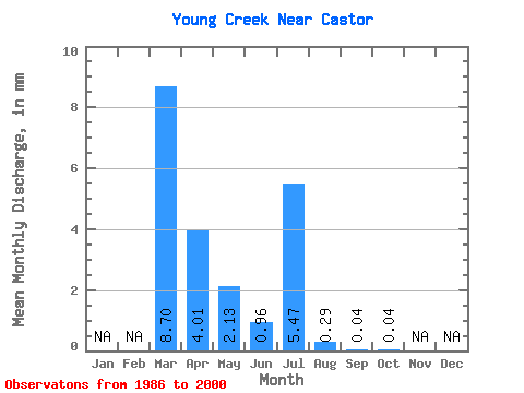
| Statistic | Jan | Feb | Mar | Apr | May | Jun | Jul | Aug | Sep | Oct | Nov | Dec | Annual |
|---|---|---|---|---|---|---|---|---|---|---|---|---|---|
| Mean | 8.27 | 3.83 | 2.03 | 0.92 | 5.21 | 0.26 | 0.04 | 0.03 | |||||
| Standard Deviation | 10.31 | 5.37 | 4.90 | 1.06 | 10.82 | 0.53 | 0.09 | 0.09 | |||||
| Min | 0.00 | 0.00 | 0.00 | 0.00 | 0.00 | 0.00 | 0.00 | 0.00 | |||||
| Max | 28.77 | 18.18 | 16.06 | 3.11 | 35.97 | 1.75 | 0.34 | 0.35 | |||||
| Coefficient of Variation | 1.25 | 1.40 | 2.41 | 1.15 | 2.08 | 2.02 | 2.08 | 3.21 |
 Return to R-Arctic Net Home Page