|
|
|||||||||||||||||
| Point ID: 5498 | Downloads | Plots | Site Data | Code: 05MB001 |
|
|
|||||||||||||||||
| Download | |
|---|---|
| Site Descriptor Information | Site Time Series Data |
| Link to all available data | |
| View: | Time Series | All |
| Units: | m3/s |
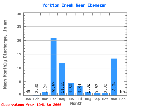
| Statistic | Jan | Feb | Mar | Apr | May | Jun | Jul | Aug | Sep | Oct | Nov | Dec | Annual |
|---|---|---|---|---|---|---|---|---|---|---|---|---|---|
| Mean | 0.05 | 0.21 | 3.66 | 2.05 | 0.81 | 0.59 | 0.23 | 0.16 | 0.16 | 2.36 | |||
| Standard Deviation | 0.03 | 0.35 | 4.09 | 4.80 | 1.82 | 1.22 | 0.47 | 0.39 | 0.43 | ||||
| Min | 0.03 | 0.00 | 0.03 | 0.01 | 0.00 | 0.00 | 0.00 | 0.00 | 0.00 | 2.36 | |||
| Max | 0.07 | 1.60 | 19.44 | 23.20 | 7.98 | 7.08 | 3.09 | 2.80 | 3.15 | 2.36 | |||
| Coefficient of Variation | 0.50 | 1.68 | 1.12 | 2.34 | 2.24 | 2.06 | 2.00 | 2.40 | 2.62 |
 Return to R-Arctic Net Home Page